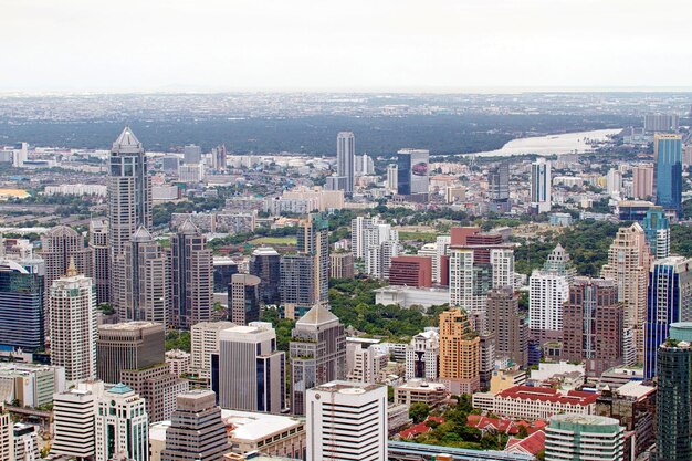
When people ask about “Atlanta city size,” they’re often wondering more than just square miles. They want to know:
How big is Atlanta on a map, how big does it feel day to day, and where exactly does “Atlanta” begin and end?
This guide breaks down Atlanta’s physical size, population, neighborhoods, metro footprint, and driving distances so you can better understand the city—whether you live here, are visiting, or are deciding where to move.
In simple geographic terms, the City of Atlanta covers:
Atlanta isn’t huge in land area compared to many sprawling Sun Belt cities, but it anchors a much larger metro region that stretches far beyond the official city limits.
When locals say “Atlanta,” they might mean:
| Term | What It Means | Rough Size / Scope |
|---|---|---|
| City of Atlanta | Official city limits (your address says “Atlanta, GA” and is in city jurisdiction) | ~136 sq. miles |
| Metro Atlanta | Multi-county region tied to Atlanta for work, housing, and transit | Over 8,000 sq. miles across many counties |
| ITP | “Inside the Perimeter” – areas inside I-285 | Core urban/inner suburban area |
| OTP | “Outside the Perimeter” – suburbs and exurbs beyond I-285 | Much of the metro population |
Key takeaway:
The city is relatively compact, but Metro Atlanta is very large and spread out. Day-to-day life can feel very different depending on whether you’re in Atlanta proper or in one of the surrounding cities and suburbs.
City of Atlanta population:
Commonly rounded to around half a million residents within city limits.
Metro Atlanta population:
Often estimated in the millions, spread across multiple counties including:
What this means for you:
Depending on traffic, crossing Atlanta can feel very different from what the map suggests.
Rough drive times in normal (non-rush hour) conditions:
During rush hour or major events, these times can easily double, especially along:
So while Atlanta isn’t enormous in square miles, traffic and congestion can make it feel much bigger.
Locals divide the region by I-285, known as “the Perimeter.”
ITP (Inside the Perimeter)
OTP (Outside the Perimeter)
For someone deciding where to live or stay, the ITP vs. OTP distinction can dramatically change commute length and how “big” Atlanta feels in daily life.
Within the city’s 136 square miles, Atlanta is divided into:
A few well-known areas and how they fit into the city’s “size”:
Downtown & Midtown:
Buckhead:
Westside (West Midtown, Upper Westside, etc.):
Eastside (Inman Park, Old Fourth Ward, Kirkwood, East Atlanta):
Even though the city is not immense in land, the neighborhood diversity can make Atlanta feel like several smaller cities stitched together.
The Atlanta BeltLine—a growing loop of trails, parks, and planned transit built on old rail corridors—has reshaped how people experience distance in the city.
Even if the map hasn’t changed, perceived distance shrinks when trails, sidewalks, and bike connections improve.
MARTA (Metropolitan Atlanta Rapid Transit Authority) helps make the city feel more manageable, especially along rail corridors.
MARTA rail lines run roughly:
If you live, work, or stay near a MARTA station, Atlanta can feel significantly smaller:
However:
Where the City of Atlanta ends and another jurisdiction begins matters for:
If you’re unsure whether an address is inside the City of Atlanta, you can:
City Hall (central point of city government):
Here’s how many residents and visitors tend to experience Atlanta’s “size” in practice:
Commuters:
Intown residents:
Visitors staying Downtown or Midtown:
Suburban families:
Here are the main points to keep in mind if you’re trying to understand how big Atlanta really is:
If you are moving to, visiting, or already living in Atlanta, understanding these layers—city limits, metro spread, traffic patterns, and neighborhood connections—will give you a much clearer picture of what “Atlanta city size” really means in everyday life.