Atlanta isn’t a mountain town, but it’s not sea level either. If you’ve ever heard it called the “City in a Forest” or noticed the rolling hills around town, you’ve already seen how elevation shapes the city.
This guide explains Atlanta, GA elevation in clear terms, how it varies across the metro area, and what it means for weather, daily life, and planning activities.
Atlanta sits on the Piedmont Plateau, between the Appalachian Mountains and the Coastal Plain.
Key elevation facts for Atlanta, GA:
| Location / Area | Approximate Elevation (feet above sea level) |
|---|---|
| Downtown Atlanta (Five Points area) | ≈ 1,050 ft |
| Hartsfield–Jackson Atlanta Airport | ≈ 1,020 ft |
| Midtown / Buckhead ridge areas | 1,050–1,200 ft |
| Higher northern suburbs (e.g., Sandy Springs, parts of Roswell) | 1,000–1,200+ ft |
| Lower-lying spots near creeks/streams | 800–950 ft |
Overall, the City of Atlanta generally ranges from about 800 to 1,200 feet above sea level, with most neighborhoods clustering around 900–1,100 feet.
Even if you don’t think much about elevation day to day, it affects:
Atlanta’s elevation is high enough to make a difference, but not so high that most people feel dramatic physical effects like they might in Denver or mountain ski towns.
Because Atlanta sits around 1,000 feet above sea level, it tends to be:
You might notice that if you drive from Savannah or Macon up to Atlanta, temperatures often drop a few degrees by the time you reach the metro area, partly due to the rise in elevation.
Atlanta’s hilly, elevated terrain helps shape where and how storms form and move:
While the city’s elevation helps protect it from coastal storm surge, it does not eliminate flood risks from heavy rainfall. Low spots near creeks, streams, and underpasses can still flood quickly.
If you live here, it’s smart to know whether your home or route to work passes through low-lying areas where water can pool during intense storms.
Atlanta’s hills and valleys create many micro-elevation zones within a small area. These differences are important when you think about drainage and flood risk.
Even at 1,000 feet above sea level, a home built at the bottom of a local slope can have drainage issues if the water has nowhere to go.
For floodplain maps, elevation data, or drainage questions in the Atlanta area, residents often work with:
They can provide guidance on local drainage, stormwater, and infrastructure that can be affected by the city’s rolling topography.
Atlanta’s elevation plus extensive tree cover give it a unique mix of benefits and challenges.
While elevation alone doesn’t guarantee clean air, the city’s position on the Piedmont can help with airflow, especially when weather systems are moving through.
Atlanta’s terrain is a big part of what makes local parks and trails interesting. You feel the elevation changes in your legs more than in your lungs.
Many Atlanta neighborhoods have rolling hills that create good natural workouts:
For most people, the city’s 800–1,200-foot elevation doesn’t cause altitude-related issues, but the ups and downs of the terrain can make runs and walks feel more intense than the distance alone suggests.
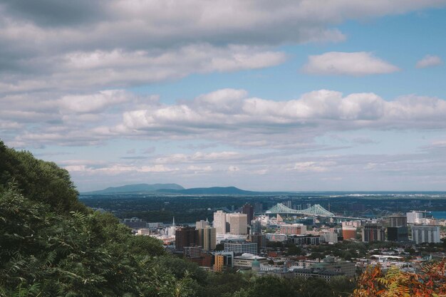
You’ll notice Atlanta’s elevation most clearly from high points and overlooks, where you can see the skyline and treetops:
If you want a more dramatic elevation change near Atlanta, Stone Mountain and Kennesaw Mountain outside the city climb significantly higher than the downtown area and are popular local hiking destinations.
Atlanta’s major airport, Hartsfield–Jackson Atlanta International Airport, sits around 1,020 feet above sea level.
For travelers:
If you’re flying into Atlanta from a high-altitude city like Denver, you’re actually descending to a lower elevation and may feel the air become a bit more humid and dense when you step outside.
As you move around the metro, small elevation changes can add up. Here’s how that plays out in everyday terms:
For residents, the most practical impacts of these elevation changes often relate to:
If you want to know the exact elevation of your home, business, or favorite park in Atlanta, you can use:
For more detailed property-level information, especially related to flood risk or building projects, homeowners and professionals sometimes work with:
They can direct you to mapping and land records that include elevation-related details.
At around 1,000 feet:
What you are more likely to notice in Atlanta is:
To stay comfortable:
If you have health concerns about physical activity, a medical professional familiar with your situation can give guidance tailored to you, but Atlanta’s elevation by itself is not extreme.
Understanding Atlanta’s elevation helps you make sense of its weather patterns, hills, and neighborhoods—and can be useful when choosing where to live, planning outdoor activities, or simply getting to know the city’s landscape more deeply.