Flooding in Atlanta, Georgia is more common than many people realize. Between sudden thunderstorms, remnants of tropical systems, and older drainage systems in some neighborhoods, even a “normal” rainy day can turn into a flooding problem in parts of the city.
If you live in Atlanta, are planning to move here, or are visiting, understanding how Atlanta flooding works—and what to do about it—can help you stay safe, protect your property, and navigate the city more confidently.
Atlanta isn’t on the coast, but it still sees regular flooding. A few key factors make flooding a recurring issue:
Heavy downpours and storms
Summer thunderstorms and slow-moving weather systems can drop a lot of rain in a short time.
Hilly terrain with low-lying pockets
Water naturally flows downhill and pools in low-lying neighborhoods, underpasses, and creek valleys.
Creeks and small rivers running through the city
Areas near Proctor Creek, Peachtree Creek, and South River can experience flooding when water levels rise quickly.
Urban development and pavement
Large amounts of pavement, rooftops, and parking lots mean less rainwater soaks into the ground and more runs straight into storm drains, which can quickly get overwhelmed.
Atlanta sees several types of flooding. Knowing which ones affect your area helps you plan and stay alert.
Flash floods are sudden, fast-moving floods triggered by intense rainfall over a short period.
In Atlanta, flash flooding often happens:
Flash flooding can turn a passable street into deep water in minutes, especially near:
While Atlanta doesn’t sit directly on a major river downtown, nearby waterways can overflow after prolonged rain:
These floods may develop more slowly than flash floods but can last longer and affect homes, apartments, and roads close to the water.
Urban flooding happens when:
This is common in:
Even if you don’t live near a creek, you can experience yard, basement, and street flooding because of drainage issues.
Flooding risk can vary block by block, but some patterns are widely recognized:
Creekside neighborhoods
Areas along Peachtree Creek, Proctor Creek, Nancy Creek, Utoy Creek, and their tributaries may see flooding when water levels rise.
Underpasses and low-lying roads
Certain underpasses around Downtown, Midtown, and industrial areas are known to collect water quickly during storms.
Older stormwater systems
Parts of historic neighborhoods can have undersized or aging pipes and inlets, making them more vulnerable during heavy rain.
For a specific property, it’s important to:
Atlanta is covered by the National Weather Service (NWS) Peachtree City office, which issues:
You can receive alerts through:
When you see a Flood Warning in the Atlanta area, take it seriously—conditions can deteriorate quickly.
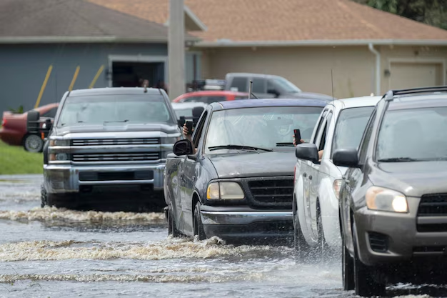
Many flooding incidents in Atlanta involve vehicles. To stay safe:
If flooding strands your vehicle and it’s safe to do so, move to higher ground and call for help.
During flooding in your Atlanta neighborhood:
Once the water recedes, there are important steps to take:
Multiple government agencies and departments play a role in managing flooding, drainage, and emergency response in Atlanta.
The Department of Watershed Management manages much of the city’s stormwater and sewer infrastructure.
You can contact the City of Atlanta for:
Typical main office location:
City of Atlanta Department of Watershed Management
72 Marietta St. NW
Atlanta, GA 30303
Customer service (commonly listed): 311 (inside city limits) or the city’s main customer service line.
For non-emergency issues (like blocked drains, standing water in streets, or missing manhole covers), Atlanta residents can typically dial 311 to reach the city’s customer service system.
You can use 311 to:
For urgent, life-threatening emergencies during a flood—such as:
Call 911 immediately and provide as much detail as possible, including landmarks and cross streets.
Understanding your specific risk is particularly important if you’re buying, renting, or developing property in Atlanta.
Flood zones are typically determined by the Federal Emergency Management Agency (FEMA). These maps show:
While FEMA maps are a starting point, they may not capture every local drainage or flash flooding problem. In Atlanta, localized street and yard flooding can happen even outside mapped floodplains.
Atlanta’s mix of older infrastructure, new development, and changing weather patterns means:
If you’re unsure about a property’s flood behavior, consider:
Here are practical steps tailored to Atlanta’s conditions:
If you’re just in town for business or vacation, flooding can still affect your plans:
Here is a simple reference for major flood-related needs in Atlanta:
| Need / Situation | Who To Contact / What To Use |
|---|---|
| Life-threatening flooding emergency | Call 911 |
| Street flooding, clogged drains, non-urgent | Atlanta 311 (from within the city) |
| City stormwater / drainage information | Atlanta Department of Watershed Management |
| Weather alerts and forecasts | National Weather Service (Atlanta / Peachtree City office) via apps, radio, or TV |
| Insurance questions about flood coverage | Your home, renters, or auto insurance provider |
Keep these numbers and resources saved in your phone, especially during stormy seasons.
Living in or visiting Atlanta, GA means experiencing plenty of rain—and occasionally, disruptive flooding. By understanding how and where flooding happens in the city, staying alert to weather changes, and knowing how to respond, you can navigate Atlanta’s flood risks more safely and confidently.