When people ask about the size of Atlanta, Georgia, they often mean more than just square miles. They’re trying to understand how big the city really feels: how far it stretches, how many people live here, how long it takes to get around, and where the real “edges” of Atlanta are.
This guide breaks down Atlanta’s size in practical, local terms—helpful whether you live in Atlanta, are visiting, or are evaluating a move to the metro area.
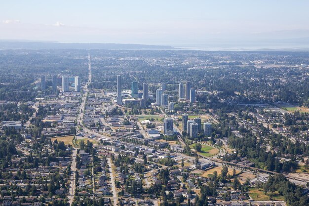
At its core, Atlanta is both a relatively compact city and the center of a huge metro area.
The City of Atlanta covers roughly:
To put that in everyday terms:
The City of Atlanta itself has a population of roughly 500,000–520,000 residents, making it:
But the Atlanta metropolitan area—what most people mean when they say “Atlanta”—is much larger, with several million residents spread across multiple counties.
Understanding Atlanta’s size means separating city limits from the metro area.
The City of Atlanta sits mostly in Fulton County, with a portion in DeKalb County. When you’re inside city limits, you pay city taxes and are served by:
City Hall is located at:
Atlanta City Hall
55 Trinity Ave SW
Atlanta, GA 30303
Main phone: (404) 330-6000
The Atlanta metro area (sometimes called “Greater Atlanta”) spreads far beyond city limits. It typically includes counties such as:
This region is many times larger than the city itself—both in land area and population—and stretches from semi-rural exurbs to dense urban cores.
Because “Atlanta” can mean different things, it helps to think in layers:
These two areas are only a few miles apart, and you can easily travel between them:
When people say “intown Atlanta,” they usually mean neighborhoods within or close to the city core, often inside or just near the I-285 Perimeter. Examples include:
These areas are still within a relatively compact radius; many are only 2–8 miles from Downtown.
I-285, often called “the Perimeter,” loops around the City of Atlanta and marks a rough line between:
From Downtown to commonly referenced Perimeter spots:
Metro Atlanta extends even farther into:
It can easily be 40–50 miles (or more) from one far edge of the metro to another.
Because people experience size through travel time, not just distance, it helps to think in terms of common trips.
In light or moderate traffic, these trips can be 10–25 minutes by car. In heavy rush hour, they can take significantly longer.
If you include the broader metro:
By car, these can be 1–2 hours or more during heavy traffic.
🚗 Tip for visitors: If you’re staying Downtown or in Midtown and plan to explore the wider region, factor in Atlanta traffic—distance alone can be misleading.
Atlanta isn’t just about miles and population; the topography and tree cover affect how big it feels.
This creates:
Atlanta has long been known as a “city in a forest.” Across much of the city:
This can make Atlanta feel less visually dense than its population would suggest, especially compared to more concrete-heavy cities.
Within city limits, Atlanta is divided into many distinct neighborhoods that each feel like their own small town.
While neighborhood boundaries aren’t always cleanly defined in miles, many intown areas are:
Examples:
This means that even though Atlanta as a region is huge, life in a given neighborhood often revolves around a very local, small-area feel.
Because of its spread-out metro area, Atlanta’s size heavily influences how people get around.
Major interstates shape how people experience distance:
In practice, these highways:
MARTA (Metropolitan Atlanta Rapid Transit Authority) serves a core portion of the region, with:
MARTA Headquarters (for system info and customer service) is located at:
MARTA Headquarters
2424 Piedmont Rd NE
Atlanta, GA 30324
Customer information line: (404) 848-5000
Transit coverage is strongest in the city core and along major corridors, so the functional size of “easy-to-reach Atlanta” without a car is smaller than the full city footprint.
Because addresses in metro Atlanta can say “Atlanta” even when they’re not in city limits, it helps to understand how jurisdictions are defined.
You may see an address like:
In these cases:
To verify whether you’re truly inside City of Atlanta:
Several counties share parts of what people consider “Atlanta.” Key county governments include:
Fulton County Government
141 Pryor St SW
Atlanta, GA 30303
Main switchboard: (404) 612-4000
DeKalb County Government
1300 Commerce Dr
Decatur, GA 30030
Main line: (404) 371-2000
These counties provide vital services—courts, some roads, property records—across large areas that are part of the broader “Atlanta” region.
Whether you’re a resident or visitor, Atlanta’s size influences everyday decisions.
Because the metro area is so spread out:
Commutes of 30–60 minutes each way are common for those living far from central job centers like Downtown, Midtown, Buckhead, and Perimeter Center.
Public schools are generally governed by county or city districts, such as:
Because the metro spans many counties, two families both saying they live “in Atlanta” may be in completely different school systems, even if they’re only a few miles apart.
APS central office location:
Atlanta Public Schools – Center for Learning and Leadership
130 Trinity Ave SW
Atlanta, GA 30303
Main line: (404) 802-3500
Despite its large footprint, Atlanta weaves in a lot of parks and trails, including:
Most intown residents are only a short drive or bike ride from at least one major park, which makes the city feel more accessible and less overwhelming in day-to-day life.
| Aspect | City of Atlanta (Core) | Metro Atlanta (Region) |
|---|---|---|
| Land area | Roughly 135–140 square miles | Many times larger; spans numerous counties |
| Population | Around 500,000–520,000 residents | Several million residents |
| Typical travel span | 30–45 minutes to cross by car (no heavy jams) | 1–2+ hours to cross outer suburbs in traffic |
| Primary jurisdiction | City of Atlanta government | Multiple county and city governments |
| Main transit coverage | Strongest near city core and MARTA rail lines | More limited farther from central corridors |
| Feel on the ground | Urban, but green and neighborhood-focused | Mix of dense, suburban, and semi-rural areas |
In everyday life, the size of Atlanta, Georgia is best understood in layers:
If you’re moving, visiting, or just trying to make sense of where you are on the map, think about which “Atlanta” you’re dealing with—city limits, intown, Perimeter, or the broader metro. That will tell you a lot about how big Atlanta really is for your day-to-day needs.