Does Atlanta Have Mountains? A Local’s Guide to the Nearest Peaks and Scenic High Points
Atlanta is known for its tree canopy, skyline, and rolling hills—not for towering peaks. So if you’re wondering, “Does Atlanta have mountains?”, the direct answer is:
No, Atlanta itself does not have true mountains, but it is surrounded by notable hills, rock outcrops, and nearby mountain ranges that are easy to reach for a day trip or weekend escape.
If you live in Atlanta, are visiting, or planning a move, here’s exactly how mountains “fit” into the Atlanta landscape—and where to go if you want big views, hikes, and cooler mountain air.
Is Atlanta a Mountain City?
Atlanta sits in the Piedmont region of Georgia—an area of rolling hills and highlands, not in the Appalachian Mountains proper.
- Elevation in much of the city is around 1,000 feet above sea level, which gives Atlanta gentle hills rather than sharp peaks.
- The true Blue Ridge Mountains, part of the Appalachian chain, begin north of the metro area, mainly in north Georgia.
So while you won’t find snow-capped peaks or ski resorts inside Atlanta, you will find:
- Prominent rocky outcrops and “mountain-like” parks within a short drive
- Real mountains within 1.5–2 hours of downtown
- Plenty of hiking, scenic overlooks, and waterfall day trips that are popular with Atlanta residents
Mountain-Like Spots Close to Atlanta
These places are not large mountain ranges, but for many Atlanta residents and visitors, they scratch the “mountain day” itch without a long drive.
Stone Mountain
Location: East of Atlanta, near Stone Mountain, GA (about 30 minutes from downtown, depending on traffic)
Stone Mountain is a massive granite dome, not a traditional mountain, but it offers:
- A steep but short hike to the summit
- Panoramic views of downtown Atlanta and the surrounding region
- Mild elevation gain that feels like a solid workout
Many locals treat Stone Mountain as their go-to close-in “mountain” hike, especially for sunrise or sunset walks.
Kennesaw Mountain
Location: Kennesaw Mountain National Battlefield Park, 900 Kennesaw Mountain Dr, Kennesaw, GA 30152
Kennesaw Mountain is a historic Civil War site and one of the higher points in the immediate metro area.
Key features:
- Several marked hiking trails of varying difficulty
- A summit with views of Atlanta’s skyline on clear days
- A mix of forested paths and open overlooks
Again, it’s not a huge peak by mountain standards, but for an after-work or weekend hill climb, it’s one of the best options close to Atlanta.
Arabia Mountain & Panola Mountain
Location: East-southeast of Atlanta in the Arabia Mountain National Heritage Area
These are granite outcrops similar in feel to Stone Mountain, but often:
- Less crowded
- More focused on nature, quiet trails, and unique rock ecosystems
You’ll find:
- Easy to moderate hikes over bare rock “moonscapes”
- Seasonal wildflowers, pools, and rare plants
- Gently sloping “summits” with broad views of the surrounding countryside
They’re great for short trips from Atlanta when you want a scenic walk without driving all the way into the Blue Ridge.
How Far Are Real Mountains from Atlanta?
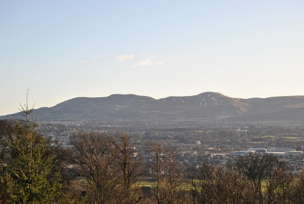
If you’re looking for true mountain ranges, head north toward the Georgia Blue Ridge. Many Atlanta residents treat these areas as regular weekend getaways.
Here’s a simple overview of popular mountain destinations and their approximate driving distance from downtown Atlanta:
| Area / Town | Driving Time (Approx.) | What You’ll Find |
|---|---|---|
| Dahlonega | 1.25–1.75 hours | Foothills, wineries, access to Appalachian Trail |
| Amicalola Falls | 1.5–2 hours | Big waterfall, mountain hikes |
| Helen / Unicoi | 1.5–2 hours | Mountain scenery, rivers, hiking |
| Blue Ridge, GA | 1.75–2.25 hours | Lakes, cabins, scenic train, higher elevations |
| Blairsville / Vogel State Park | 2–2.5 hours | Classic Blue Ridge mountain scenery |
| Brasstown Bald | 2.25–2.75 hours | Highest point in Georgia, sweeping views |
Driving times vary with traffic, but in general:
- Within 60–90 minutes: You reach foothills and smaller peaks.
- Within 2–2.5 hours: You’re in serious mountain country with steep hikes, overlooks, and cooler temperatures.
Popular Mountain Destinations for Atlanta Residents
Dahlonega and the Southern Appalachian Foothills
Distance: About 65–75 miles north of Atlanta
Dahlonega is often seen as a gateway to the mountains:
- Access to trailheads that connect to or sit near the Appalachian Trail
- Rolling foothills that rise into more substantial peaks just north of town
- A convenient first stop if you’re leaving Atlanta after work for a weekend in the mountains
Amicalola Falls State Park
Location: 418 Amicalola Falls State Park Rd, Dawsonville, GA 30534
Why Atlantans love it:
- Home to one of the tallest waterfalls in the Southeast
- Multiple trail options, including routes that connect toward the Appalachian Trail approach
- A real mountain feel with steep climbs and forested ridges
It’s a common choice for day trips from Atlanta, especially if you want to combine waterfalls and mountain hiking.
Blue Ridge, GA
Distance: Roughly 90–100 miles north of Atlanta
Blue Ridge is a classic mountain town destination for Atlantans, offering:
- Lake Blue Ridge and surrounding peaks
- Access to the Chattahoochee National Forest
- Plenty of cabins and trailheads scattered through nearby hills
For many city residents, this area offers the closest thing to a “true mountain vacation” without leaving Georgia.
Brasstown Bald: Georgia’s Highest Point
Location: Near Blairsville and Hiawassee, GA
Brasstown Bald is the highest natural point in Georgia, with:
- An observation area (shuttle or steep walk from parking)
- Expansive views of the Blue Ridge and, on clear days, into neighboring states
- Cooler temperatures that often feel like a different season than Atlanta
It’s a longer day trip from the city, but when people in Atlanta say they’re going to “the mountains,” this region is exactly what they mean.
How Atlanta’s Terrain Feels Day to Day
Even though Atlanta isn’t in the mountains, the city doesn’t feel flat.
Rolling Hills Across the City
As you drive or walk around Atlanta, you’ll notice:
- Streets that rise and fall gently, especially in neighborhoods like Virginia-Highland, Midtown, and Buckhead
- Ridges and small valleys that influence where streams, parks, and neighborhoods sit
- Views where, from certain spots, you can see the skyline rising above a sea of trees
This hilly landscape is part of why many visitors are surprised to learn how much elevation change they encounter during an ordinary walk or jog.
High Points and Scenic City Views
If you want city views without leaving Atlanta, you have options:
- Jackson Street Bridge for skyline views (not a mountain, but a high vantage point)
- Elevated spots in Freedom Park or along the Atlanta BeltLine Eastside Trail
- Certain points in Buckhead and West Midtown, where higher ground gives you long sightlines
These aren’t mountains, but they offer that “overlooking the city” feeling you might be craving.
When Is the Best Time for Mountain Trips from Atlanta?
For Atlanta residents and visitors, season matters when planning mountain outings.
Spring and Fall
- Cooler temperatures than Atlanta
- Wildflowers in spring and vibrant foliage in fall
- Often considered the most comfortable seasons for hiking around the Blue Ridge
Summer
- The mountains can be noticeably cooler than Atlanta, sometimes by several degrees
- Popular for lake days, waterfalls, and shaded trails
- Higher elevation can offer some relief from Atlanta’s heat and humidity
Winter
- Mountain areas can be colder, windier, and occasionally icy
- Good for clear views, since trees shed their leaves
- Snow is not guaranteed, but it’s more likely in the high elevations than in Atlanta
Because mountains are relatively close, many Atlantans watch the forecast and pick their day based on conditions, especially in winter.
Getting from Atlanta to the Mountains: Practical Tips
If you’re starting in Atlanta—whether from Downtown, Midtown, or the airport area—these general tips can make mountain trips smoother:
- 🚗 Leave early: Morning departures help you avoid traffic on GA-400, I-75, and I-85, especially on weekends.
- ⛽ Fuel up before you leave metro Atlanta: Gas stations become more spread out on rural routes.
- 🥾 Plan your trailheads: Many popular spots near Atlanta and in north Georgia have limited parking, especially on sunny weekends.
- 🧥 Pack layers: Conditions in the mountains can be cooler and changeable, even if Atlanta feels warm.
If you’re visiting and staying near central Atlanta, many people rent a car for a day or two specifically for these mountain drives, since public transit does not extend into the Blue Ridge region.
Who to Contact for Local Outdoors Information
For Atlanta-based and north Georgia mountain information, these public agencies are common reference points:
Georgia Department of Natural Resources (DNR) – Oversees state parks and some outdoor recreation resources.
- Headquarters: 2 Martin Luther King Jr. Dr. SE, Suite 1252 East, Atlanta, GA 30334
- Main Phone: (404) 656-3500
Georgia State Parks & Historic Sites (under DNR) – Manages parks like Amicalola Falls and Vogel State Park.
- General Info Line (often used by visitors): (770) 389-7286
Chattahoochee-Oconee National Forests (U.S. Forest Service) – Covers much of north Georgia’s mountain terrain.
- Supervisor’s Office: 1755 Cleveland Hwy, Gainesville, GA 30501
- Phone: (770) 297-3000
These offices can provide up-to-date details on trails, closures, weather concerns, and park regulations before you drive up from Atlanta.
Bottom Line: What “Mountains” Mean When You’re in Atlanta
- Atlanta does not have true mountains inside the city, but it has noticeable hills, elevated viewpoints, and rocky outcrops like Stone Mountain, Kennesaw Mountain, Arabia Mountain, and Panola Mountain within a short drive.
- For real mountain ranges, Atlantans typically head north to the Blue Ridge Mountains in north Georgia, usually 1.5–2.5 hours away.
- Whether you’re living in Atlanta or visiting, you can easily plan day trips or weekend getaways to enjoy mountain scenery, waterfalls, and higher elevations—without leaving the state.
