Where Collier Heights Is in Atlanta (And How to Get Around It)
Collier Heights is a historic neighborhood on the west side of Atlanta, known for its strong community roots and its role in Black middle-class history. If you’re trying to figure out where Collier Heights is in Atlanta, how to get there, or how it relates to other parts of the city, this guide breaks it down clearly.
Where Exactly Is Collier Heights in Atlanta?
Collier Heights is located in Northwest Atlanta, in Fulton County, within the City of Atlanta limits.
In simple terms, you’ll find Collier Heights:
- West of Downtown Atlanta
- North of I-20
- Just south of Donald Lee Hollowell Parkway (US-78/278)
- East of I-285 (the Perimeter)
If you picture a map of Atlanta:
- Downtown is roughly in the center.
- Collier Heights is a bit to the northwest, not too far inside the Perimeter.
- It sits between major westside corridors like Donald Lee Hollowell Pkwy NW and Hamilton E. Holmes Dr NW.
Many GPS systems and map apps recognize “Collier Heights, Atlanta, GA” as a neighborhood name, so you can usually type that in directly.
Key Streets and Boundaries Around Collier Heights
Collier Heights doesn’t have a single official border line everyone uses, but most people and local maps agree on a general area.
Common reference points include:
- North: Donald Lee Hollowell Pkwy NW
- South: Near MLK Jr. Dr SW and the neighborhoods closer to I-20
- East: Areas approaching Center Hill and West Lake neighborhoods
- West: Just inside I-285, not far from the Hamilton E. Holmes exit
Major roads you’ll hear associated with Collier Heights include:
- Donald Lee Hollowell Pkwy NW
- Hamilton E. Holmes Dr NW
- Collier Dr NW
- Hightower Rd NW (older name still used by many locals)
- Finley Ave NW and surrounding residential streets
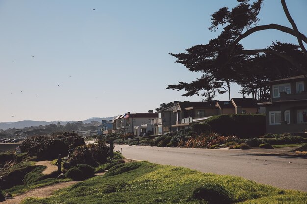
You’ll mostly see single-family homes, tree-lined streets, and residential blocks rather than dense commercial strips inside the neighborhood itself.
How Far Is Collier Heights From Other Atlanta Landmarks?
Here’s a simple distance-and-direction overview to help you place Collier Heights on the city map. Distances and times are approximate and assume typical, non-rush-hour conditions.
| From / To | Approx. Distance | Typical Drive Time | Direction From Collier Heights |
|---|---|---|---|
| Downtown Atlanta (Five Points area) | 6–7 miles | 10–15 minutes | Southeast |
| Midtown Atlanta | 7–8 miles | 15–20 minutes | East/Southeast |
| Hartsfield–Jackson Atlanta Airport | 14–16 miles | 20–30 minutes | South/Southeast |
| Buckhead (Lenox area) | 10–12 miles | 20–25 minutes | Northeast |
| Georgia Tech campus | ~6 miles | 10–15 minutes | East |
| Mercedes-Benz Stadium | ~5 miles | 10–15 minutes | Southeast |
These are general estimates. Travel times can lengthen during rush hour, especially along I-20, I-285, and the Connector (I-75/85).
How to Get to Collier Heights by Car
Because Collier Heights sits between major interstates and westside corridors, it’s fairly easy to reach by car from most parts of Atlanta.
From Downtown or Midtown Atlanta
- Take I-20 West toward Birmingham.
- Exit at Hamilton E. Holmes Dr NW / Holmes Dr.
- Head north on Hamilton E. Holmes Dr NW.
- Collier Heights is located off Hamilton E. Holmes, especially around Collier Dr NW, Boulder Park Dr, and nearby residential streets.
Alternative route:
- Head west on Donald Lee Hollowell Pkwy NW from Downtown.
- Continue west; as you pass neighborhoods like Center Hill and Grove Park, you’ll approach the northern side of Collier Heights.
From the Airport (Hartsfield–Jackson)
- Take I-85 North to the Downtown Connector (I-75/85).
- Continue north, then merge onto I-20 West.
- Exit at Hamilton E. Holmes Dr NW and head north.
- Turn into the residential streets (for example, Collier Dr NW or side streets off Hamilton E. Holmes) to reach the heart of Collier Heights.
From I-285 (the Perimeter)
- On the west side of the Perimeter, take the exit for I-20 East if coming from the north, or I-20 West if coming from the south, then:
- Use Hamilton E. Holmes Dr NW exit and head north, or
- From I-285 at Donald Lee Hollowell Pkwy NW, exit onto Hollowell Pkwy and head east. Collier Heights is to the southeast of that corridor.
Getting to Collier Heights by MARTA
If you prefer public transit, Collier Heights is served mainly by MARTA bus routes, with rail connections nearby.
Nearest MARTA Rail Station
The closest major rail station is generally:
- Hamilton E. Holmes Station (Blue Line)
70 Hamilton E. Holmes Dr NW
Atlanta, GA 30318
From there, riders typically:
- Walk or bike into parts of Collier Heights if close enough, or
- Transfer to a MARTA bus heading into the neighborhood’s interior.
Check current MARTA maps and schedules for specific bus route numbers and timing, as routes and frequencies can change.
Using Bus Routes
Common patterns to reach Collier Heights by MARTA bus:
- Take the Blue Line train to Hamilton E. Holmes Station.
- Transfer to a bus heading along Hamilton E. Holmes Dr NW, Donald Lee Hollowell Pkwy NW, or Collier Dr NW.
- Get off near your exact destination within the neighborhood.
If you’re not sure of the best route, you can:
- Use trip-planning tools in popular maps apps, or
- Call MARTA Customer Service at 404-848-5000 for route and schedule assistance.
Navigating Within Collier Heights
Once you’re in the general area, here’s what to expect:
- Streets are primarily local residential roads.
- Many interior streets are hilly, tree-lined, and curving, so it’s useful to rely on a GPS app for exact addresses.
- You’ll see street names like Collier Dr NW, Baker Ridge Dr NW, Browntown Rd NW, Habershal Dr NW, and many cul-de-sacs and side streets.
If you’re visiting for a specific purpose (for example, a home, church, or community event), it helps to:
- Get the exact street address in advance.
- Confirm whether you’re on the NW side (most of Collier Heights is in the NW quadrant; omitting “NW” can sometimes send navigation to the wrong part of town).
Is Collier Heights Inside the Atlanta City Limits?
Yes. Collier Heights is within the City of Atlanta, in Fulton County.
That means:
- City services such as Atlanta Police Department, Atlanta Fire Rescue, and City of Atlanta sanitation typically serve the area.
- Residents vote in Atlanta municipal elections and are subject to City of Atlanta ordinances.
If you ever need to verify jurisdiction (for example, about utilities, zoning, or permits), you can contact:
City of Atlanta – Customer Service / ATL311
- Dial: 3-1-1 (inside city limits) or 404-546-0311 (outside ATL)
- They can confirm addresses and which services apply to a specific location in Collier Heights.
Nearby Neighborhoods and Areas
Understanding what’s around Collier Heights can also help you place it:
- Center Hill & Grove Park – To the east, along and near Donald Lee Hollowell Pkwy NW.
- West Lake – Southeast of Collier Heights, closer to I-20 and the West Lake MARTA station.
- Adamsville / Fairburn Heights – To the southwest, closer to I-20 and the I-285 interchange.
- Westview & Mozley Park – Further south along I-20 but part of the broader Westside area.
If someone says they’re “on the Westside near Collier Heights,” they’re generally talking about this northwest quadrant of Atlanta, west of Downtown but inside the Perimeter.
Tips for Visitors and New Residents
A few practical pointers if you’re heading to Collier Heights for the first time:
- ✅ Use a full address, including “NW.” Atlanta has many similarly named streets; “NW” vs “SW” can matter a lot.
- 🚗 Plan around traffic on I-20 and I-285. Morning and evening rush hours can significantly extend drive times to and from the neighborhood.
- 🚍 Check MARTA schedules in advance. Bus frequencies in residential neighborhoods can be more limited than main corridors.
- 📍 Verify your destination’s neighborhood. Some nearby communities share similar street names; confirming “Collier Heights” with your host or contact can avoid confusion.
In everyday terms, if you’re in Atlanta and wondering where Collier Heights is:
It’s a historic, primarily residential neighborhood on the northwest side of the city, just west of Downtown, north of I-20, and inside I-285, centered around Hamilton E. Holmes Dr NW, Collier Dr NW, and Donald Lee Hollowell Pkwy NW.